Home > Apps > Maps & Navigation > スーパー地形 - GPS対応地形図アプリ
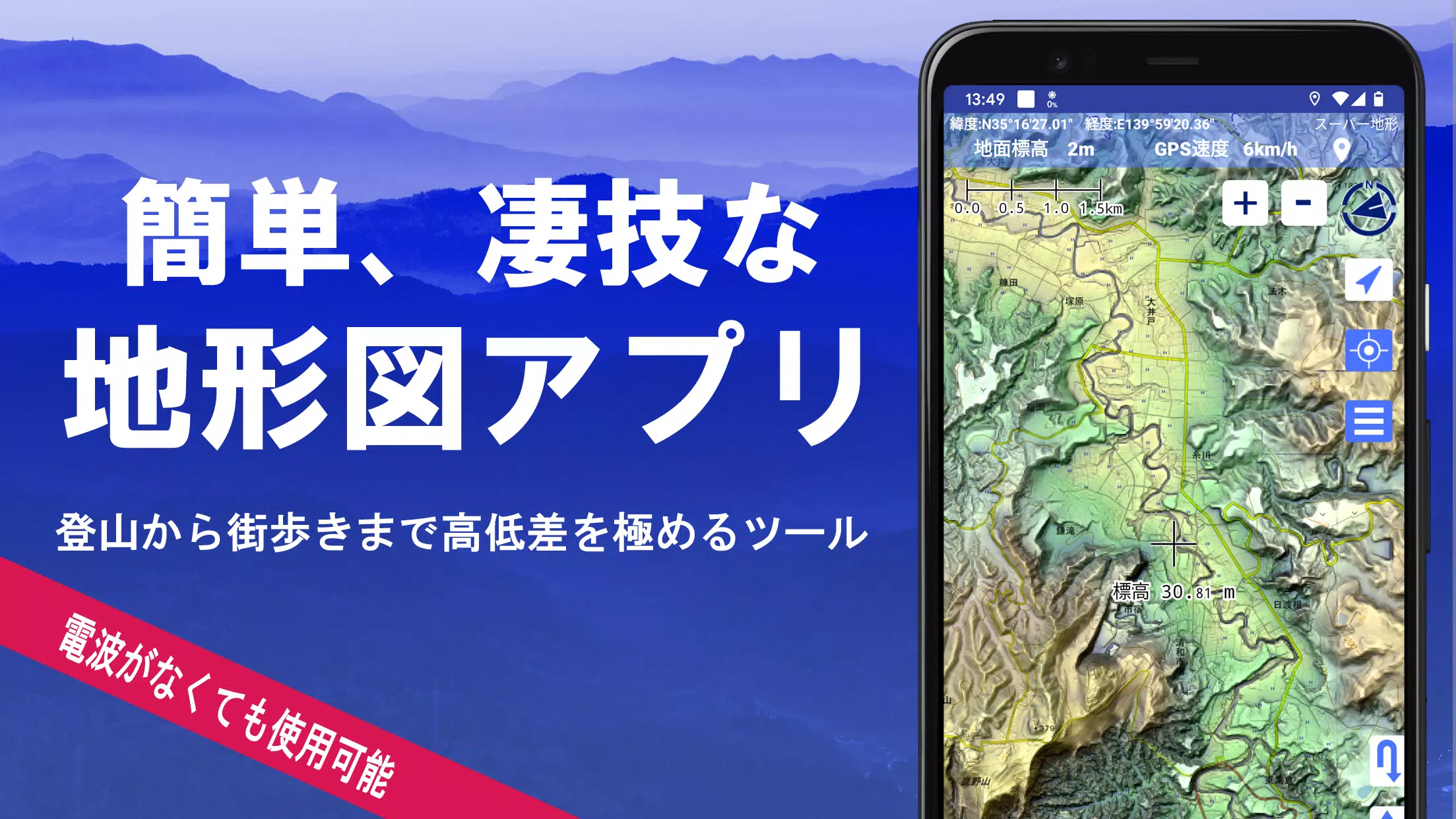
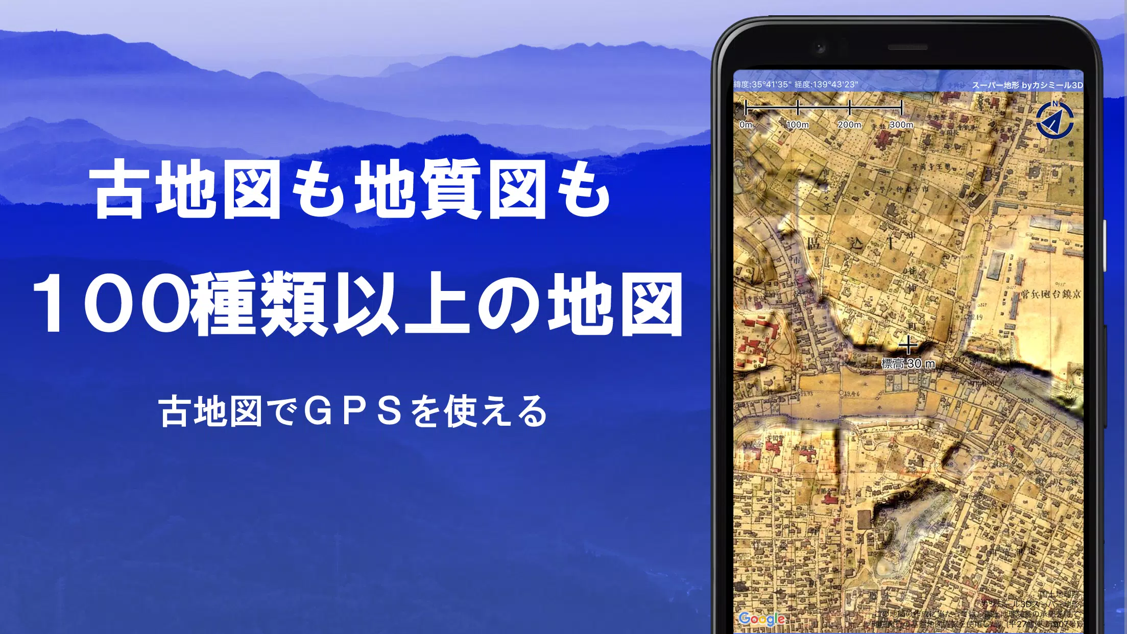
Discover the power of over 100 types of maps, including the renowned Geographical Survey Institute map, designed to enhance your experience from mountain climbing to leisurely strolls around town. This versatile app, which received the prestigious 2018 Japan Cartographic Society Award for Best Work, leverages "super terrain data" to emphasize terrain details using unique technology. Users can access a wide range of maps from the Geospatial Information Authority of Japan, including topographic, geological, old, past and present, and prewar topographic maps (Ordnance Survey Department).
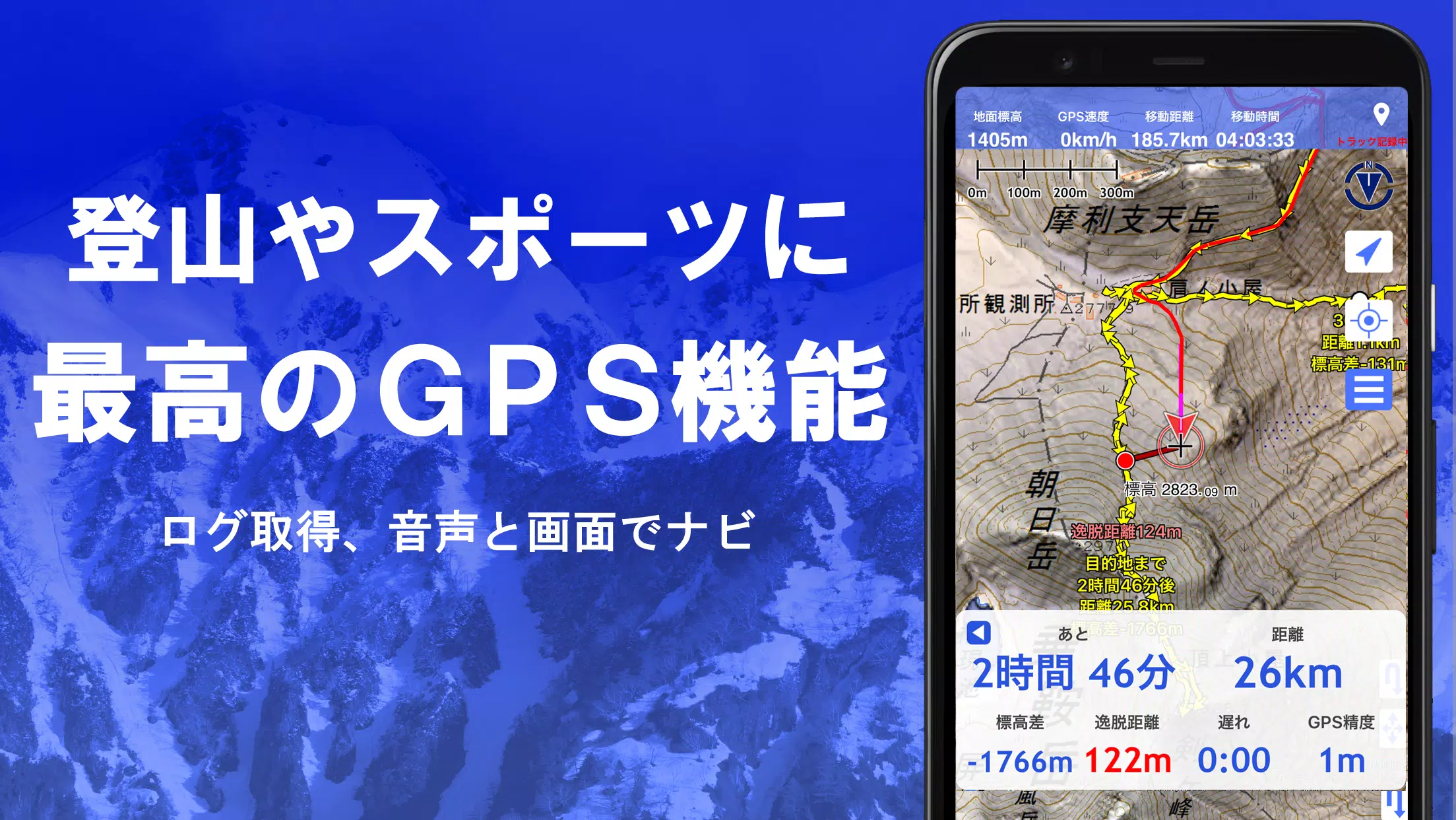
Enhance your outdoor adventures with the app's robust GPS functionality, which allows you to record tracks (trajectories) and supports GPX log input/output and editing. Whether you're navigating urban landscapes or scaling mountain peaks, the app offers comprehensive support with features like GPS navigation (with audio), data recording, and editing. Additionally, the visibility determination function aids in creating cross-sectional diagrams, observation, and radio communication, with the capability to display buildings.
Experience the 360° panoramic view function, which includes a mountain identification feature to help you recognize mountain names. You can also view the sun, moon, and GPS points. The app's GPS function, bulk map download, and map cache capabilities ensure a seamless offline experience, perfect for areas without radio signals. You can associate photos with specific points, display contour lines generated from elevation data, and show MGRS grid (UTM grid).
Further enhance your mapping experience with the ability to read, display, and edit GIS data from GeoJSON files, draw shapes, and use the app overseas. Map printing and PDF output are available, and the app supports a dark theme for comfortable viewing.
A Wealth of Maps at Your Fingertips
Explore over 100 types of maps, including combinations of our own super topographic data, maps from the Geospatial Information Authority of Japan, and hazard maps. Note that aerial photographs may not be available in all locations depending on the age group, with "Latest" and "around 1974" offering relatively wide coverage. Enjoy a free 5-day trial of maps using super terrain data after installing the app.
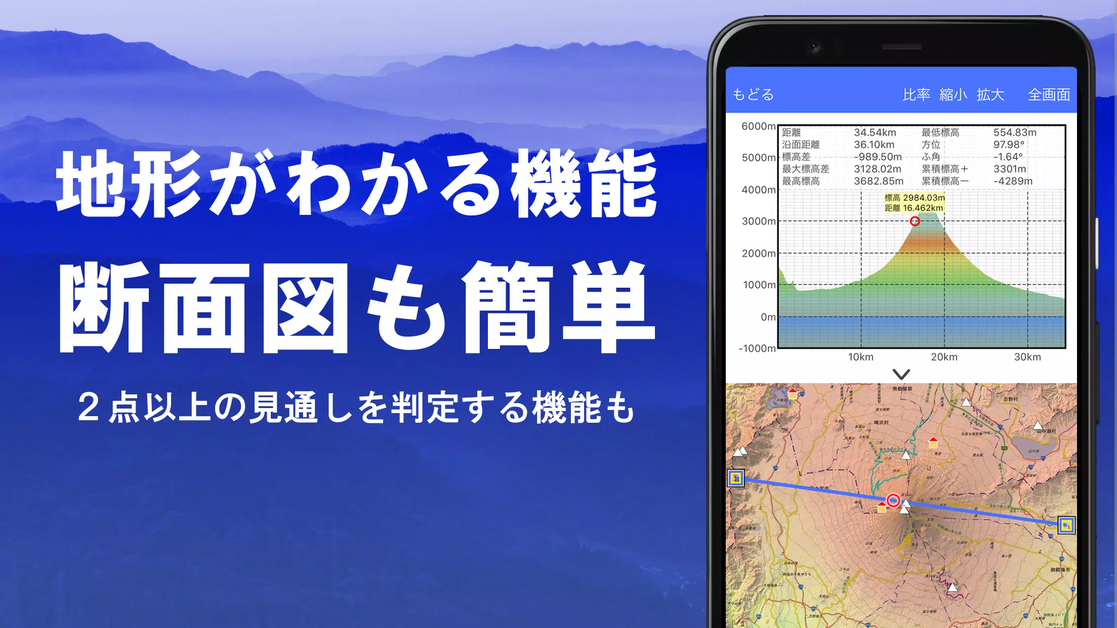
Creating Cross Sections and Outlooks
Effortlessly draw cross sections through any point on the map and utilize the visibility judgment function, familiar from Kashmir 3D, which accounts for Earth's curvature and atmospheric differences. This feature is invaluable for route planning during climbs, assessing wireless visibility, and understanding terrain. Where PLATEAU building data is available, you can create cross-sectional views that include buildings.
Elevation Palette Function
Customize your map experience with the elevation palette function, allowing you to change the map background color in 1cm increments to your preferred gradation.
Panoramic View
Enjoy panoramic observation maps that display mountain names from any location on the map. The 360-degree panorama links with your smartphone's compass, aiding in mountain identification. You can also view the sun and moon, including moon phases, which is perfect for spotting Diamond Fuji and Pearl Fuji. Additionally, you can see GPS points and draw panoramic views of mountains overseas.
GPS Function
Utilize your smartphone's GPS to obtain location information and record tracks with high-precision position measurement suitable for serious mountain climbing and outdoor activities. Display recorded tracks graphically with parameters like elevation gain, speed, time, and elapsed time. The point alarm function alerts you with voice and alarm sounds when approaching a designated point. You can also display photos linked to specific points and send the map center position to NaviCon.
GPS Track Summary Playback
Replay track logs all at once with the GPS track summary playback function. It automatically displays photos stored on your smartphone that match the shooting times of the tracks, with icons indicating photo locations that can be viewed by tapping.
GPS Navigation Function
Navigate along preset tracks using the Track Navi function, which alerts you with voice or alarm if you deviate from the track, ensuring you stay on course during climbs. The app also supports route navigation for urban walks and point navigation for targeting specific locations.
GPS Data Editing Function
Manage GPS-related point, route, and track data with folder organization displayed in an easy-to-read tree format. Create tracks directly on the map and import/export in GPX format from mountain climbing sites.
Map Usage Outside the Service Area (Offline)
Use maps even in areas without signals, such as during mountain climbing, with the bulk download function that allows you to download all scale maps of a specified plot. The cache function ensures you have maps available when needed.
Map History Function
The app remembers locations you've viewed, allowing you to return to previous spots easily.
Custom Map Compatibility
Import and use custom maps cut out with Kashmir 3D's map cutter, displaying your own maps and scanned maps. When using the map cutter, divide each image into approximately 256 x 256 images and send the created kmz file to Super Terrain via email or Cloud Drive.
GeoJSON Compatibility
Display and edit points, linestrings, and polygons from GeoJSON format files, and draw new shapes.
Print/PDF Output
Print any area of the map at a specified scale or create a PDF.
Cooperation with Other Apps
Input and output GPS data in GPX, KML, and GDB formats, enabling data exchange with other apps, the Kashmir 3D software on your PC, and trajectory data from mountain climbing sites.
Backup Function
Back up all data in the app (excluding cached maps) and remove it from your smartphone. Restore data even if you delete the app or your smartphone malfunctions. An automatic backup feature using Google Drive ensures up-to-date backups. For detailed instructions, please refer to the manual.
About Billing Function
Some functions, such as maps using super terrain data, GPS track functions, and cross-sectional views, require in-app purchases. After payment, the number of search results for place name searches increases.
- Fees: Annual payment: 780 yen/year
- Free Trial: Enjoy a 5-day free trial after first installing the app. After 5 days, some features and maps will no longer be available unless you make a purchase. You will not be charged unless you perform a purchase operation. To purchase, select [Settings] - [Purchase to remove functional restrictions] within the app.
- Confirmation and Cancellation: Check or cancel automatic updates by opening Google Play, pressing "Regular Purchase" from the menu, and selecting "Super Terrain."
- Price Revision: Prices may be revised due to future feature enhancements. It is advantageous to purchase early.
Terms of Use
The copyright holder and developer assume no responsibility for the results of operating this application. When starting GPS for the first time, you will be prompted to allow the use of location information services. Continuous use of the GPS function will drain the battery, so if your device is used for emergency communication, carry a spare battery. An easy-to-understand explanation of the navigation function is available in PDF format at https://www.kashmir3d.com/online/superdemapp/superdem_navi.pdf. Note that some smartphones may interrupt or fail to record tracks due to power-saving functions forcibly closing background apps, a common issue across various apps. Turning off the screen while using Super Terrain may allow recording to persist temporarily, but this is not a fundamental solution.
Additional Game Information
Latest Version4.6.17 |
Category |
Requires AndroidAndroid 5.0+ |
Available on
|

スーパー地形 - GPS対応地形図アプリ Screenshots


Top Download
More >


Trending apps
-

- Youtube Biru
- 4.3 Entertainment
- YouTube Biru APK: Elevate Your Mobile Entertainment ExperienceIntroductionYouTube Biru APK revolutionizes mobile entertainment on Android platforms, offering an array of features tailored to enhance your viewing experiences. Developed by the Vanced team, this app stands out from the crowd by delivering ad-free enjoyment and functionalities not found in the standard version. Emphasizing user autonomy and an enhanced interface, YouTube Biru transforms everyday entertainment into an engaging and uninterrupted journey.How to Use YouTube Biru APKTo begin enjoying the enhanced features of YouTube Biru, follow these simple steps:Visit the official website or search for "YouTube Vanced" in your web browser to locate the application.Download the Vanced Manager app, your gateway to managing installations and updates for YouTube Biru.Install it on your Android device; the user-friendly interface guides you through the setup process.Once installed, follow the instructions to install YouTube Biru and unlock a superior viewing experience compared to traditional apps.Features of YouTube Biru APKYouTube Biru APK enriches your mobile experience with a suite of exceptional features designed to elevate your video watching sessions. Here are the main capabilities that set YouTube Biru apart from standard apps:Ad-Free Experience: Enjoy your videos without interruption. YouTube Biru eliminates all advertisements, offering you a seamless viewing experience that keeps you focused on the content, not the commercials.Offline Viewing: Never miss a video due to connectivity issues. With YouTube Biru, download your favorite videos to watch anytime, anywhere. This feature is perfect for keeping entertainment on hand, even when you're offline.Background Playback: Listen to music or continue watching your videos while you engage with other apps or even when your screen is off. Background Playback transforms your device into a versatile entertainment tool, allowing you to multitask without pausing your video.Dark Mode: Protect your eyes and enhance your viewing experience during nighttime browsing with Dark Mode. This user-friendly feature provides a comfortable viewing environment in low-light conditions, making it easier on your eyes and helping conserve battery life on your device.Premium Features for Free: YouTube Biru offers all the perks of a premium subscription without any cost. Enjoy advanced functionalities such as picture-in-picture mode and enhanced playback features, all for free.Best Tips for YouTube Biru APKMaximize your experience with YouTube Biru by implementing these practical tips, designed to enhance usability and enjoyment of the app:Customize Video Quality: Optimize your viewing experience by adjusting the video quality settings in YouTube Biru. This feature allows you to save data on mobile connections or enjoy high-definition clarity when connected to Wi-Fi, ensuring the best balance between quality and performance.Gesture Controls: Take advantage of the intuitive gesture controls in YouTube Biru to make your viewing more comfortable and efficient. Swipe to adjust volume or brightness directly on the playback screen, enhancing your control over the app’s usability.Double-Tap to Skip: Quickly navigate through videos with the double-tap feature. Tap twice on the right side of the screen to skip forward, or on the left side to rewind. This feature is particularly useful for skipping to your favorite scenes or bypassing content you’re less interested in.Explore Playlists: Dive into a variety of curated playlists in YouTube Biru that cater to different moods and genres. Exploring playlists can introduce you to new content aligned with your interests, organized by themes or creators within the app.YouTube Biru APK AlternativesIf you're exploring other options beyond YouTube Biru, here are three alternative apps that also offer enhanced video viewing experiences:NewPipe: A lightweight alternative for those who cherish privacy and open-source software. NewPipe does not require any Google Play Services or YouTube API, functioning independently. This app provides features such as ad-free viewing, background playback, and the ability to download videos. Its minimalistic approach ensures smooth performance even on older devices.VLC for Android: Not just a versatile media player, VLC for Android includes capabilities to stream videos directly from YouTube. While it primarily excels in playing local files, its YouTube streaming feature allows users to watch videos without ads, leveraging VLC’s robust playback tools. This makes it a great secondary option for users who need a multifunctional media player.FreeTube: An app focused on privacy and a user-friendly experience. FreeTube allows you to watch YouTube videos without ads and without Google tracking your viewing habits. It is designed to keep your viewing preferences anonymous, making it ideal for users who prioritize their online privacy while enjoying content.ConclusionAs you explore the possibilities of enhancing your video streaming experience, YouTube Biru APK stands out as a superior choice. With its user-focused design, it offers features that transform how you interact with video content on your Android device. Whether you're looking to eliminate interruptions, enjoy videos in high quality, or simply manage your viewing preferences without constraints, YouTube Birumakes it possible. Don't hesitate to download this exceptional app and start enjoying a premium video experience without any cost. Discover a new standard of video streaming that aligns perfectly with your needs and preferences.
-

- Tevi - Private Live Streaming
- 4.2 Tools
- Tevi: Private live streaming that revolutionizes the way you share and enjoy video content Tevi is the ultimate private streaming app that puts you in control of your live broadcast and creates a personalized experience for your audience. Unlike public video hosting platforms, Tevi offers rich branding and advertising options, best-in-class customer support, and enhanced security measures. Whether you're a business, an educational institution, or just want to connect with family and friends, Tevi has you covered. Not only can you easily monetize your content, viewers can also interact with broadcasters through real-time interactions, quiz games, or even show their love by sending digital gifts. Join the Tevi community today and redefine the way you stream and connect. If you have any questions, our dedicated team will contact you at [email protected] To assist you. Features of Tevi - Private Live Streaming: Private Streaming: Tevi allows users to create private live streaming channels and share access with their target audience, ensuring exclusive content for specific groups such as family, friends, businesses, educational institutions, etc. Easy to use: Tevi is an easy-to-use platform that allows broadcasters to set up a live channel and start streaming in minutes with no technical expertise. Customization and Control: Unlike public video hosting platforms, Tevi offers more customization and control over content, allowing broadcasters to have branding and advertising options, personalized video layers, and secure streaming. Interactivity: Viewers can interact with the broadcaster during a live event, ask questions, and even play trivia games created by the host. There are also features that allow viewers to support their favorite broadcasters by sending hearts, stars and other gifts to show appreciation. Ad-free experience: Tevi provides an ad-free streaming experience that eliminates distractions and ensures users a seamless viewing experience. Global Payments and In-App Purchases: Tevi facilitates global payments and offers in-app purchases, allowing users to purchase digital gifts to celebrate moments and show appreciation to broadcasters. Conclusion: With Tevi - Private Live Streaming, broadcasters can easily create private live channels and share exclusive content with their target audience. The app offers customization, control and branding options, as well as interactive features for your audience. Additionally, Tevi ensures an ad-free streaming experience and users can support broadcasters through in-app purchases. Download Tevi now to start streaming and enjoy private, interactive content!
-

- Microsoft Family Safety
- 4.2 Personalization
- [ttpp]Microsoft Family Safety: Empowering Families with Digital Well-being and SafetyExperience peace of mind and foster healthy digital habits with the Microsoft Family Safety app. This comprehensive tool enables you and your family to thrive both online and offline.Key Features for Digital and Physical Safety:- Parental Controls:Monitor your children's online activity by setting filters for inappropriate apps and games, ensuring their web browsing remains safe on Microsoft Edge.- Screen Time Management:Establish limits for specific apps and games on Android, Xbox, and Windows devices. Manage screen time across multiple devices on Xbox and Windows.- Activity Reporting:Gain insights into your family's digital usage through weekly email summaries. Use these reports to initiate discussions about online habits with your children.- Location Sharing:Locate loved ones easily with the GPS family location tracker. Save frequently visited places like work and school for added convenience.- Driving Safety:Promote safer driving habits with driving reports that track speed, braking, acceleration, and phone usage while driving. This data helps you understand your family's on-road behavior.- Privacy and Permissions:Your privacy is paramount. Microsoft does not sell or share your location data with insurance companies or data brokers, ensuring your family's information remains secure.Benefits of Microsoft Family Safety:- Comprehensive Digital Safety:Protect your loved ones online with parental controls, screen time management, and activity reporting.- Physical Well-being:Stay connected and monitor your family's whereabouts with location sharing and driving safety features.- Peace of Mind:Gain peace of mind knowing your family is safe and their digital habits are healthy.- Easy Monitoring and Management:Monitor and manage your family's online activities effortlessly with a user-friendly interface.- Privacy-Focused:Microsoft prioritizes data protection, providing transparency and control over data collection and usage.[yyxx]Call to Action:Empower your family with the Microsoft Family Safety app today. Download now to create a safe digital environment, foster healthy habits, and ensure your loved ones' well-being.
-

- WPS WPA2 App Connect
- 4.2 Tools
- WPS WPA2 App Connect: Enhanced Network Security with Google-Friendly ContentWPS WPA2 App Connect empowers you with unparalleled network security by identifying potential risks and vulnerabilities. This feature-rich utility leverages the WPS protocol to scan your Wi-Fi for password and WPS weaknesses, bolstering its defenses.Features:Thorough Network Security Assessment: The app meticulously checks your Wi-Fi network for security flaws, including password and WPS vulnerabilities, ensuring a secure online experience.Seamless WPS Protocol Integration: Connect effortlessly to Wi-Fi networks using the WPS protocol, which employs an 8-digit pin number typically pre-configured in your router. This intuitive feature streamlines the connection process.Vulnerability Detection: Employing advanced algorithms and default pins, the app evaluates your network's susceptibility to intrusion attempts. This feature empowers you to identify and mitigate potential risks.Convenient Password Access: Access and view stored Wi-Fi passwords on your device with ease. This functionality proves invaluable when you forget your password or need to share it securely.Educational Focus: The app underscores its educational mission, serving as a valuable tool for understanding the significance of network security. It promotes responsible usage and strongly discourages misuse.Marshmallow Compatibility: In alignment with Google's requirements, the app requires location permissions on Android 6 (Marshmallow) and subsequent versions. This ensures a seamless user experience on the latest operating systems.Conclusion:WPS WPA2 App Connect is an indispensable tool for safeguarding your Wi-Fi network. Its comprehensive security checks, WPS protocol compatibility, and convenient password access features empower you to maintain a secure and protected online environment. The app's emphasis on education aligns perfectly with Google's search engine guidelines. Click the download button today to enhance your network security and embrace the benefits of this Google-friendly app.
-

- Dreamehome
- 4 Lifestyle
- Dreamehome App: Unleash the Potential of Your Robot Floor CleanerIntroducing the Dreamehome App, the ultimate companion for your robot floor cleaner, empowering you with a range of advanced features to elevate your cleaning experience.Unlock Customization and Convenience:With the Dreamehome App, you can effortlessly control your robot remotely, adjusting parameters, checking schedules, and more. Access real-time information about its status, error messages, and accessory usage.Create a Detailed House Map:Map your home's layout to guide your robot's navigation, ensuring thorough cleaning in each room or area. Define "No-Go Zones" to restrict access to specific areas for safety and control.Targeted Cleaning and Flexible Scheduling:Quickly clean small, specific areas that require immediate attention. Set up a customized cleaning schedule that aligns with your preferences, including specific days, times, and zones.Advanced Features for Enhanced Functionality:Upgrade your robot's software seamlessly via OTA technology. Enable voice control integration with Amazon Alexa or Google Assistant for even greater convenience. Share control with family members for collaborative cleaning.Conclusion:The Dreamehome App transforms your robot floor cleaner into a smart and efficient household helper. Customize cleaning tasks, create cleaning schedules, and monitor your robot's performance with ease. Experience a new level of convenience and efficiency in your cleaning routine with the Dreamehome App.For more information, reach out to [email protected] or visit our website at www.dreametech.com.
-

- Google Meet
- 4.6 Communication
- Google Meet: The video calling app launched by Google Google Meet is the video calling app launched by Google that allows you to connect with anyone through your smartphone. This tool has a very simple interface that provides you with all the necessary features to enjoy smooth video calls with one or more users simultaneously. Make free online video calls on your Android device With Google Meet, you can easily make free online video calls without signing up. All you need is a Google Account to take advantage of all the benefits of this tool, and if you don't want to add a phone number to find your contacts, you never have to. Plus, for added privacy, you can create meetings without sharing your email address. Creating a meeting in Google Meet is very easy On the Google Meet homepage, you will see a section where you can easily start a meeting. All you have to do is select an email address and within a few seconds you will receive a valid invitation link. You can also share the link to each meeting directly with other participants in this section to save time. Create a personalized avatar and add a virtual background Like similar tools, Google Meet allows you to use a custom avatar so you don’t have to reveal your identity during video calls. Likewise, the tool provides you with different backgrounds to customize each setting to the maximum extent. View your calendar Google Meet allows you to schedule all your meetings in Google Calendar. This is useful for setting dates and start and end times for video calls. This way, if you're used to working with your teammates remotely, you'll never miss an online meeting. Protect your privacy Google Meet is a secure app, as proven by the fact that Google provides you with advanced end-to-end encryption on every video call. You must grant access to the microphone and camera to start a call. The tool will also ask for access to your address book so that the tool can retrieve the numbers of people you might invite to each meeting. Download Google Meet APK for Android devices and enjoy one of the best free video calling apps for smartphones. Easily create a meeting or join any existing link and connect with multiple people in every session using HD video and high-fidelity sound. Requirements (latest version) [ttpp]: Android 6.0 or higher FAQ How to activate Google Meet? To activate Google Meet, you need to enter your phone number and request an activation code. After receiving the text message, enter the code to complete registration and start making calls. How do I view my call history in Google Meet? To view your Google Meet call history, click Settings > Account > History. Here you will see all the calls you have made and received. To view the history of an individual contact, open their profile, click More Options, then click View Full History. How do I invite someone to Google Meet? To invite someone to Google Meet, open the app, select your contact list, and tap the person you want to invite. Your SMS app will automatically open with a default message you can send to that person.
Latest APP
-
- GPS, Maps, Voice Navigation
- 4.9 Maps & Navigation
- Discover the ultimate Navigation app designed to meet all your travel needs! Whether you're driving, walking, or cycling, our app provides accurate navigation, real-time traffic updates, and turn-by-turn directions to ensure you reach your destination quickly and efficiently.Key Features:Maps & GPS
-

- Trafi
- 2.0 Maps & Navigation
- Discover the ultimate travel companion with the Trafi app, where all your transport needs are seamlessly integrated into one convenient platform. Whether you're commuting to work or exploring new cities, Trafi ensures you move around effortlessly. Here’s what you can achieve with our innovative app:
-

- Red Taxi
- 3.8 Maps & Navigation
- Safe and Affordable Rides with Red TaxiExperience the city like never before with Red Taxi, your go-to fleet for safe, high-quality transportation. With just a few minutes' wait, a taxi will be at your doorstep, ready to whisk you away to your destination. Say goodbye to the hassles of public transp
-

- 台北捷運Go
- 4.0 Maps & Navigation
- The "Taipei MRT Go" app has been revamped to offer a seamless integration with various modes of transportation. It now includes direct links to Taojie, Gaojie, High-Speed Rail, Taiwan Railway, Maokong Gondola websites, and download interfaces for YouBike and Taipei Haoxing apps, making it easier for
-

- Car Mobile - Motorista
- 3.1 Maps & Navigation
- For drivers looking for a streamlined, efficient, and secure experience, our app is the perfect solution. It's designed exclusively for registered customers, ensuring safety and ease of use for every ride. FOR DRIVERS ONLY Our app empowers drivers to effortlessly receive new ride requests, boosting
-

- Kigo - Parkimovil
- 2.9 Maps & Navigation
- Parkimovil is your ultimate digital solution for parking, access control, parking meter payments, and more. Our app streamlines, processes, and facilitates interactions and payments across various mobility nodes, offering an innovative approach to managing the offer, registration, control, and payme
-

- KML Converter
- 4.6 Maps & Navigation
- View and Convert your KML to CSV, KMZ, GPX, GeoJson, TopoJsonView and Convert your CSV, KMZ, GPX, GeoJson, TopoJson to KMLWhat is KML?KML, or Keyhole Markup Language, is a file format used to display geographic data in Earth browsers like Google Earth. Structured as a tag-based system, KML follows t
-

- ØstfoldReise
- 4.7 Maps & Navigation
- Plan your journey with ØstfoldReise - the ultimate tool for seamless travel planning in Østfold, Oslo, Akershus, Vestfold, Buskerud, Telemark, Oppland, and Hedmark. Whether you're traveling by bus, tram, Metro, ferry, or train, ØstfoldReise helps you navigate from point A to B effortlessly. Get a co
-
- Doko?
- 4.8 Maps & Navigation
- Doko? is a free Maps & Navigation app designed to enhance your travel experience in Japan by providing easy access to essential amenities like garbage bins, smoking areas, and restrooms. Ideal for tourists, Doko? ensures a convenient and hassle-free journey through Japan.Key Features:FINDWith Doko?,